


Wind measurement
Wind resource: Wind measurement for wind farm site selection
To make sure that the location of wind farms is the one that allows us to make the most of wind energy, a wind measurement study must be carried out. We tell you how it is done, why it is so important and the latest technological developments in this regard.

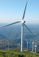
Wind energy is one of the most promising renewable energy sources in the world. It is generated through the use of wind turbines that convert the kinetic energy of the wind into electrical energy. Therefore, in order to make the most of this energy source, it is necessary to select suitable sites for the installation of wind turbines and this depends to a large extent on accurate wind measurement.
Wind measurement is essential for selecting the most suitable sites for wind turbine installation to achieve maximum performance. These wind measurement studies seek to determine wind speed and direction using a range of specialised instruments, such as anemometers, which calculate wind speed, wind vanes and barometers.
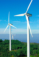
Wind speed and wind direction are critical factors affecting the performance of wind turbines. As wind speed increases, the power generated by the wind turbine also increases. In addition, wind direction is also important for choosing the best sites as the turbines are designed to be oriented towards the prevailing wind direction. Therefore, it is important to know the proper orientation.
These preliminary measurements of the wind resource are of vital importance in order to correctly estimate the expected yields over the lifetime of the wind farm and to know where to locate the most efficient wind turbine positions.
How wind measurement surveys are carried out: the wind atlas
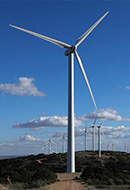
In order to assess and select potential sites for a future wind farm, studies are first carried out on a wind atlas. This is a high-resolution iso-wind map (lines connecting points of equal average wind speed) showing the average annual wind speed and wind direction at each point, based on modelling with satellite reanalysis data. This wind atlas highlights areas of interest from a wind development point of view, i.e., areas with annual wind speeds above 6 m/s at approximately 80m height.
In addition to wind, a wind atlas can also provide information on other important factors that may influence wind energy generation, such as the topography of the area, the presence of obstacles that may affect the wind, such as buildings or trees, and the density of vegetation in the area.
Once the possible restrictions or unusable areas have been filtered out, what are known as Greenfield zones are obtained, those with the greatest potential, for which it will be necessary to carry out a more detailed study of the restrictions, the orography and, above all, to adjust and calibrate the wind atlas. These measurements can be carried out with meteorological stations made up of steel towers at heights of between 80 and 120 metres, on which meteorological sensors are installed at different heights that enable the wind speed at the hub height of the projected wind turbines to be characterised very precisely, the predominant direction to be known in order to design the implementation of wind turbines, the variation of the wind with height and the calculation of air density, among the main functions.
At Iberdrola we also currently have remote devices known as Lidar, which are more effective, efficient, safe and have a lower environmental and economic impact.
Wind resource
-

Avoids the risks associated with working at heights, as the weather stations are manually assembled at heights ranging from 80 to 120 metres.
-

Less environmental and visual impact.
-

Reduces processing time to initiate measurements.
-

Reduces measurement time at each point.
-

Reduces cost as a single Lidar device is equivalent to two 80-metre measurement towers.
-

Allows measurements to be taken up to 300 metres in height.
-

Measurements are also bankable and approved by international standards IEC (International Electrotechnical Commission), certifiers and technologists.
 SEE INFOGRAPHIC: Advantages of LIDAR devices
What are LIDAR devices and how do they work?
LIDAR is the acronym for Light Detection and Ranging and is the device we use at Iberdrola to measure wind speed and direction at different heights using light pulses. And how does this device work? It emits pulses with a high-frequency vertical laser that, by bouncing off the aerosols contained in the air and based on the principle of the Doppler effect, measures the speed and direction of the wind at heights of between 40 and 300 metres. The Doppler effect is the change in the frequency of a wave as a consequence of the motion of the source relative to its observer.
The main advantages of this technology are the following:
- It avoids the risks associated with working at heights, as the weather stations are manually mounted at heights ranging from 80 to 120 metres.
- Less impact on the environment and visual impact.
- It reduces the processing time for initiating measures.
- Reduces measurement time at each point.
- It reduces the cost as a single lidar device is equivalent to two 80-metre measuring towers.
- Measurements can be taken up to a height of 300 metres.
- The measures are also bankable and approved by the international standard IEC (International Electrotechnical Commission), certifiers and technologists.
These measurements allow for horizontal, vertical and temporal extrapolation of the measurements obtained at some points along each of the locations and hub heights of the planned wind turbines, thus reducing the uncertainty about the expected long-term production of the wind project.