


Geological surveys: Keys to dam engineering
Iberdrola's commitment to dam safety
Iberdrola projects Water Hydroelectric power
Comprehensive geological studies are essential for making informed decisions to ensure the long-term viability and safety of a hydropower plant. Furthermore, the integration of geological data into advanced numerical models allows engineers to develop dams that are safe, efficient and sustainable.

December 2023

Approximately 3 minutes

Global Renewable O&M Technical Services at Iberdrola


Detailed geological site studies are essential to ensure the long-term safety and efficiency of dams and reservoirs. Geology plays a crucial role in the development of these facilities, as it affects various aspects of the design, construction and operation of these facilities. It influences, for example, processes as important as the selection of its location or the structural typology of the dam, bearing in mind other important aspects such as seismic risk, the permeability of the terrain, the erosion and stability of the slopes of the reservoir or the sedimentary load carried by the river.
Crucial phases in the construction of dams
Environmental Impact Assessment and Sustainability
Environmental impact assessment (EIA) and sustainability assessment (which also considers the economic and social aspects of the project) are key processes in the development of a dam, as they seek to assess its influence on the environment and society and to mitigate potential negative impacts.
An assessment is first carried out in the early stages of the project, prior to dam construction. Potential environmental impacts are identified and a framework for the assessment is established. Detailed data is collected on the natural and social environment of the affected area. This requires a thorough knowledge of geology, hydrology, biodiversity, air and water quality, as well as socio-economic aspects of the local communities. Subsequently, the potential environmental and social impacts associated with the construction and operation of the dam are assessed while consultations with local communities, stakeholders and experts are carried out to obtain their views and concerns. Feedback from the local community can influence the design and mitigation of impacts.
During the study, different options and locations for the dam are analysed, evaluating alternatives that minimise environmental and social impacts, and developing mitigation plans for them. These may include measures to preserve biodiversity, protect soil and aquatic habitat, ensure the safety of structures or manage the relocation of affected communities.
In addition, after dam construction, a continuous monitoring programme is implemented to assess the effectiveness of mitigation measures and address any unanticipated impacts.
Geological analysis and site selection: the importance of geology in the construction of dams
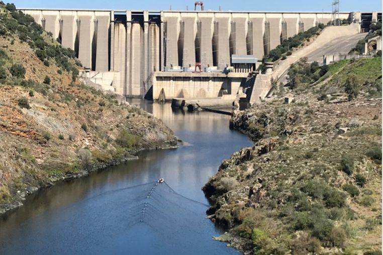
The selection of the dam site (called "downstream boundary") is one of the most important processes of the project and is strongly influenced by the geology of the area in question, which determines the suitability of the site, affecting key aspects of the design and construction of the facility. The strength and stability of the supporting terrain —preferably rock— are essential factors in estimating the behaviour of the dam when in operation. If the substrate is competent, it can support the dam's own weight and resist the hydrostatic thrusts generated by the reservoir; but if the underlying ground is weak, additional geotechnical work may be required to strengthen the dam's foundation to ensure its long-term stability. It is also important to analyse the permeability of the subsoil in order to minimise seepage under the dam once it is loaded, which could affect its stability.
Underwater geophysical survey in a reservoir basin to determine the thickness of the water being transported.
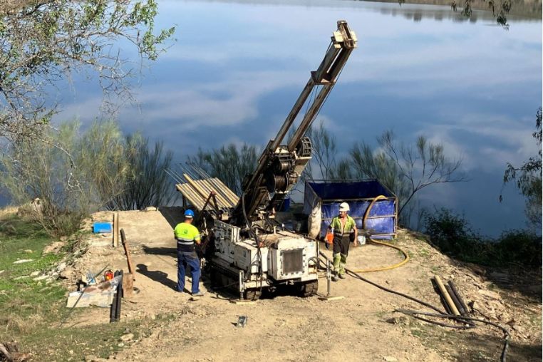
Probe drilling a geotechnical subsurface investigation borehole, close to a dam.
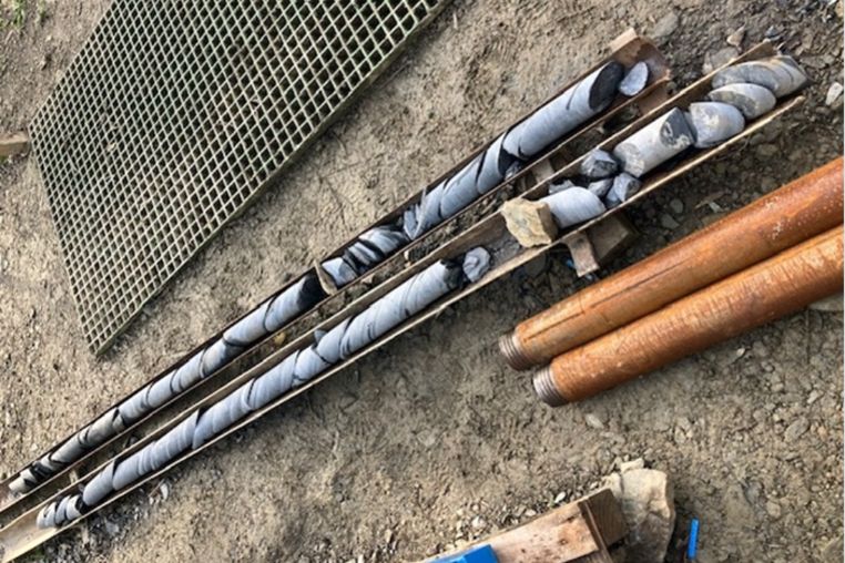
Example of ground recovered from a research survey.
For site selection it is also very important to know the seismic activity, which is directly influenced by the geology. Studies are carried out to identify seismogenic faults in the vicinity of the dam and its reservoir, to assess the seismic history and the probability of future earthquakes and their magnitude. Geological information is crucial to design structures resistant to seismic events and to implement measures to mitigate this risk.

The importance of the geological characterisation of the site of a dam can also be extended to the rest of the infrastructures that make up hydroelectric power plants: accesses, water intakes and outlets, hydraulic conduits (canals or tunnels) and power stations, all of which are closely related to the land that supports and surrounds them.
Advanced Engineering Design and Modelling
Engineers must take into account the geological characteristics of the site to ensure the safety, stability and proper selection of the different dam typologies. To this end, geotechnical models are used to assist in the selection of the typology and allow for optimisation of the dam design. These models are used, for example, to simulate and interpret the behaviour of the ground under new and different loads and conditions with respect to its natural state, and its interaction with the dam itself. The shear strength and deformation of the foundation under dam and reservoir induced loads are analysed, which helps to foresee potential problems and optimise the design. Similarly, geological and geotechnical models help predict how the ground will respond to seismic forces, allowing the design of structures resistant to foreseeable seismic events, without compromising safety.

Also important is the hydro-sedimentological modelling, which makes it possible to predict the nature and regime of sediment accumulation in the reservoir, so that efficient management measures can be planned.
About Iberdrola's dams
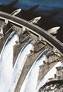
Aldeadávila Dam
The Aldeadávila hydroelectric power station is located in a wide canyon in the lower section of the river Duero as it passes through the province of Salamanca and is considered one of the most important hydroelectric engineering works in Spain in terms of installed capacity and electricity production. The complex has two power stations: Aldeadávila I, commissioned in 1962 with a gross head of 139.80 metres; and Aldeadávila II, in operation since 1986 with a gross head of 137.83 metres.
Due to its orography, the Duero river, with rock walls over 400 metres high, offers very good conditions for reservoirs. In addition, the great flow that the river acquires at this point, together with the existing difference in height in this stretch of the Duero river, is what allows Aldeadávila to be the hydroelectric power station with the highest production in Spain. It is also one of the highest dams in Spain, with a height of 139.50 metres and a crest length of 250 metres. The main structure of this facility is underground: it has 12 kilometres of tunnels.
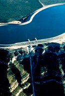
Cortes - La Muela Dam
The Cortes-La Muela complex is located in an impressive canyon of the Júcar River. First, in 1983, the Cortes dam was installed, with a height of 116 metres and arch-gravity type, and La Muela I. In 2015, the complex was extended with the construction of the hydroelectric power plant La Muela II, which turned this complex into the one with the highest installed power in Europe. On the other hand, while the Cortes II plant was created from a cylindrical artificial well, the La Muela I and La Muela II plants are underground in a cavern and 635,000 m3 and 270,000 m3 were excavated for their construction, respectively.
In these two hydroelectric power plants, the lower reservoir is connected to the upper reservoir thanks to two penstocks that bridge a 500-metre drop, one 4.80 metres in diameter and 950 metres long in the case of La Muela and the other 5.45 metres in diameter and 850 metres long in the case of La Muela II. These pumping stations are the only mass electricity storage systems and allow efficient management of peak hour coverage.
Tâmega Dam
The Tâmega hydroelectric project involves the construction of three power plants: Gouvães, Daivões and Alto Tâmega, which will be built on the Tâmega river, a tributary of the Douro located in northern Portugal, near Porto. The creation of the Daivões reservoir has involved the construction of a bridge some 200 metres long and 35 metres high. The Daivões reservoir is the lower reservoir of the Gouvães hydroelectric pumping station. This power station is reversible, i.e. it allows water from the Daivões reservoir to be stored in the Gouvães reservoir, taking advantage of the more than 650 metres difference in height between the two. In this way, energy can be pumped out when there is excess production and recovered when necessary.
The first filling of the Daivões reservoir was completed in March 2021. This is the culmination of a major design and construction project for a concrete gravity arch dam with a height of 77.5 metres and a crest length of 265 m. The concrete for this hydroelectric complex is being cast in the Gouvães quarry. The Gouvães quarry, which has already produced more than 2 million tonnes of aggregates, is being used for the concrete for this hydroelectric complex. The first filling of the Alto Tâmega dam is currently underway. The dam is of the vault type, 104.5 m high and has a reservoir capacity of 132 Hm3.